Dhaka, May 16 – The deep depression over Southeast Bay and adjoining Southwest Bay intensified into cyclonic storm AMPHAN at 9 pm on Saturday, the Met Office said in a weather bulletin.“It is likely to intensify further and move in a north-westerly direction,” the forecast said.
It said a trough of westerly low lies over West Bengal and adjoining area.
Bangladesh Meteorological Department (BMD) has forecast rain or thundershower accompanied by temporary gusty or squally wind for parts of Rangpur, Mymensingh and Sylhet divisions.
It said the weather may remain mainly dry with temporary partly cloudy sky elsewhere over the country.
Inclement weather at a time when paddy harvesting is going on will be an unwelcome development for farmers. Rain and storm at this time could jeopardise the harvest.
Meanwhile, a mild heat wave is sweeping over Khulna division and the regions of Madaripur, Gopalgonj, Rangamati, Rajshahi, Pabna and Patuakhali may continue, the Met Office said.
Temperature during the day and night may remain nearly unchanged.
In the last 24 hours until 6 pm, Netrokona recorded the highest rainfall of 44mm. During this period, the highest temperature was recorded at 37.8 degrees Celsius in Jashore. Netrokona recorded the lowest temperature at 21.4C.
In its extended outlook for the next five days, the Met Office said rain or thundershowers activity may increase. – UNB
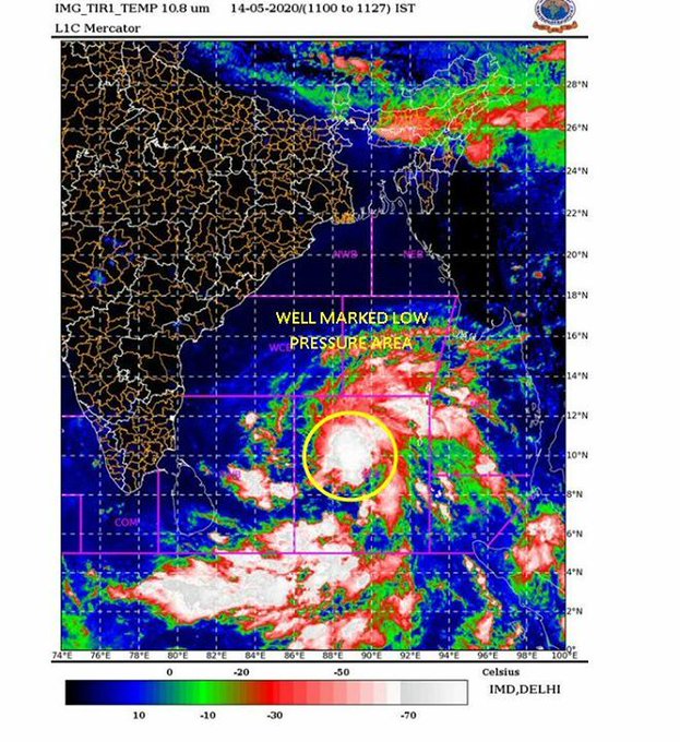
The Indian Express reported: The India Meteorological Department (IMD) has declared a cyclone alert for the Indian coastline across the Bay of Bengal as a low-pressure area has formed over southeast Bay of Bengal and adjoining south Andaman sea. The cyclone will be named ‘Cyclone Amphan’.
“Yesterday’s low-pressure area over southeast Bay of Bengal and adjoining south Andaman Sea lay as a well-marked low-pressure area over southeast Bay of Bengal & neighbourhood with associated cyclonic circulation extending up to mid-tropospheric levels,” the IMD said in a bulletin.
The low-pressure area is “very likely” to concentrate into a depression over central parts of south Bay of Bengal on May 15 and “further intensify into a cyclonic storm” over the same region by 5:30 pm on May 16, the IMD bulletin further said.