The United Kingdom is an island nation with more than 11,000 miles of coastline.
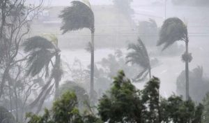
Although the solitude provided by the surrounding seas and oceans has been – at times – the UK’s greatest defence, it can also pose the greatest threat to the estimated three million people that live within its coastal reaches. The danger of the sea was brought home for thousands of people in the Netherlands, Belgium and the UK during the night of 31 January 1953. A massive storm surge swept into unsuspecting, sleeping communities, claiming the lives of 2,551 people, damaging almost 50,000 properties and killing tens of thousands of livestock. Described as one of the UK’s worst natural disasters in modern times, the Great North Sea Flood inundated 1,000 miles of coastline and left 380 square miles of land submerged under seawater, ruining vast areas of valuable farmland. “1953 exposed the weaknesses of the east coast flood defence system in a dramatic and tragic manner,” explained Phil Rothwell, head of flood and coastal risk strategy for the Environment Agency. “Following on from that, there was significant investment in the weak points and where the problems were likely to be greatest.” He told BBC News that it led to a re-evaluation of defences around the entire coastlines of England, Wales, Scotland and Northern Ireland. One of the outcomes from the process was the design and construction of the Thames Flood Barrier, which began operating in 1984. “Although we tend to think of the 1953 flood as a South-East event, the impact was felt all along the [North Sea] coast,” he explained. While 307 people in England died in the flood, 19 people in Scotland also lost their lives. ‘Extreme storm surge’: Chris Hughes, a researcher at the National Oceanography Centre and the University of Liverpool, explained that a storm surge referred to a rise in sea-level on top of the tide. “Storm surges of some kind happen every day,” he told BBC News. “It only gets unpleasant for people when you have an extreme storm surge, which is what we are seeing at the moment. “This requires a combination of usually low atmospheric pressure – this effectively sucks up the sea surface – and wind blowing along or towards the coast, which piles the water up. “In the UK, we tend to get the extreme high tides near the equinoxes – around September and March. “So if this weather event had happened at a different time of year, it could have produced an even bigger storm surge,” Prof Hughes suggested. But could we see a repeat of the events of 1953? Today, an estimated three million people live in coastal areas, of which 1.3 million are deemed to be in areas at-risk from flooding. Phil Rothwell said that lessons from the storm surge tragedy 60 years ago had been learned and a “significant programme of investment had been carried on since that time”. For example, he said: “The peak level forecast for this current event in Hull is 5.2 metres. The previous highest level was 5.0m, so it is higher than we have seen before. “We have put a barrier in at Hull and improved the flood defences [to withstand a peak] to 6.3m, so even though the peak forecast is higher than it has ever been recorded before, it is still significantly below
some of the defences that have been put in place.” But, he added: “But that is not universally true, in some places where flood defences have been built or improved, they might ‘overtop’ in instances such as this one.” Managing the risk Within the UK, a range of flood defence systems are used. These include hard structures, such as concrete seawalls; beach replenishment and “soft engineering”, including “managed realignment” of the coastline. Overall, about 44% of the England and Wales coastline and 6% of Scotland’s coastline is defended by one of the above systems. When deciding on the scale and size of defences, Mr Rothwell said the Environment Agency focused its efforts on areas with the highest risk of “wave attacks and future overtopping”. He also added that consideration was also given to what is situated behind the defences, such as large urban areas where the risk to human life and economic activity was highest. “There is a very well worked system to determine where risk is at its highest and where you therefore have to invest.” In recent years, investment in coastal defences has doubled. A report for the UK government projected that figure would have to double again by 2080 as a result of concerns over the impact of climate change. Mr Rothwell acknowledged that, in the future, the cost and scale of updating coastal flood defences was unlikely to be sustainable. But he said that there were a number of other ways of controlling the risk from flooding. “When you are rebuilding houses or building towns that have a flood risk, whether inland or on the coast, then you need to be able to build them in such as way to be resilient. “If you do this then you can still get out, escape and cause less damage, so there is a lot that can be done in terms of planning and development to ensure that the risk is reduced. Be alert: He said that another importance facet in the ways to reduce the risk to people and properties was via a flood warning system. The Environment Agency says more than a million people have signed up to receive its alerts. The alerts are also disseminated via traditional and social media. In 1953, no such system existed. “In 1953, there were people that were being flooded in the north of England at the same time that people in Canvey Island were getting ready for a night out because the communication system just was not there,” observed Mr Rothwell. “In terms of communication and in terms of data, we now have far, far better forecasting systems that allow us to understand when a surge of this sort is likely to occur.” In order to predict the occurrence of storm surges, scientists have developed computer models that run on supercomputers at the Met Office.
The UK Coastal Monitoring and Forecasting (UKCMF) service is a partnership between NOC, the Environment Agency, the Met Office, and CEFAS, the fisheries agency. Prof Hughes explained: “The main advance [in coastal flood alert forecasting] has been computer power. “In the past, it was people looking at charts and doing some analytical calculation to try and work out what the storm surges would do. “This gradually evolved into numerical models on computers with finer and finer (resolution), and this was also combined with better and better weather predictions. “We are now starting to look at things such as ‘ensemble forecasting’, so rather than run the best estimate of what you think is going to happen in the future, you try several different ones with slight changes to the starting conditions – you get a better picture of how reliable your forecast is.”By Mark Kinver – BBC Environment