Dhaka, May 19 – The peripheral winds of the very severe cyclonic storm Amphan have already started hitting the Bangladesh coasts blowing its clouds that are causing rainfall. The Bangladesh Meteorological Department has said the destructive cyclone may grow more severe and cross the coast between Khulna and Chittagong Tuesday night with windspeed up to 185 kilometres per hour. The Indian Meteorological Department has said Cyclone Amphan is only the second super cyclone over the Bay of Bengal in two decades after the one that savaged Odisha in 1999, claiming nearly 10,000 lives
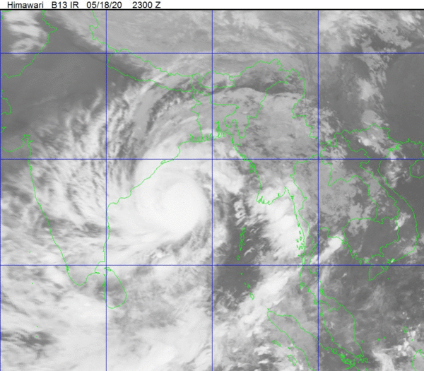
The very severe cyclonic storm“AMPHAN”over West-central Bay and adjoining area moved northwards and intensified into a SuperCyclone Storm over the same area(near Lat 14.5°N & long 86.0°E) 06 PM today (18may, 2020). It is likely to intensify further and move in a northerly direction and then re-curve north-northeastwards and may cross Bangladesh coast between Khulna-Chattogram during the late night 19 May 2020to afternoon/evening 20 May 2020.
The super Cyclonic Storm “AMPHAN” lay over Westcentral Bay and adjoining area. At 09 am today (19.05.2020), it’s distance was about 845 km Southwest of Chattogram port, 795 km Southwest of Cox’s Bazar port, 730 km South-Southwest of Mongla port and 725 km South-Southwest of Payra port, The Bangladesh Meteorological Department (BMD) has said in its special weather bulletin.
IMD said – The extremely severe cyclonic storm Amphan has now turned into a super cyclonic storm and is spiralling towards Indian shores, prompting the West Bengal and Odisha governments to start evacuating people from vulnerable areas.
The Indian National Disaster Response Force (NDRF) has deployed 37 teams in the coastal areas of Bengal and Odisha. Amphan is expected to make landfall on West Bengal coast on May 20 as an extremely severe cyclonic storm.
In its bulletin on Tuesday, IMD said the super cyclonic storm Amphan over West-central and adjoining East-central Bay of Bengal moved nearly north-northeastwards with a system speed of 14 kmph during past six hours.
At 2.30 am on May 19, Amphan lay over Westcentral Bay of Bengal about 570 km south of Paradip (Odisha), 720 km south-southwest of Digha (West Bengal) and 840 km south-southwest of Khepupara (Bangladesh).
Be prepared to face any situation arising out of severe weather condition.
Now a super cyclonic storm, the India Meteorological Department (IMD) forecast that the storm will lose some of its intensity on the way and slam West Bengal as a very severe cyclonic storm during landfall between Digha in West Bengal and Hatiya Islands in Bangladesh on Wednesday evening.
It will still have a maximum sustained wind speed of 165 to 175 kmph gusting up to 185 kmph, the weatherman said.
Evacuations have already begun with moved from coastal areas of Odisha where Jagatsinghpur, Kendrapara, Bhadrak and Balasore were likely to experience heavy rainfall accompanied by high-velocity winds, particularly on May 19 and 20.
Official reports reaching Kolkata said 40,000 people have already been evacuated from South 24 Parganas district.